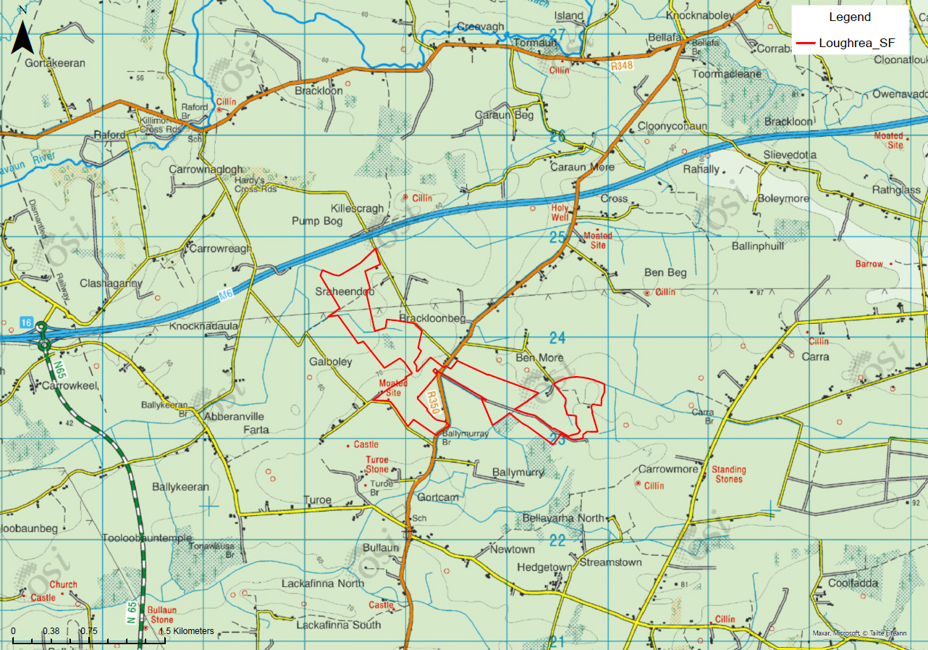
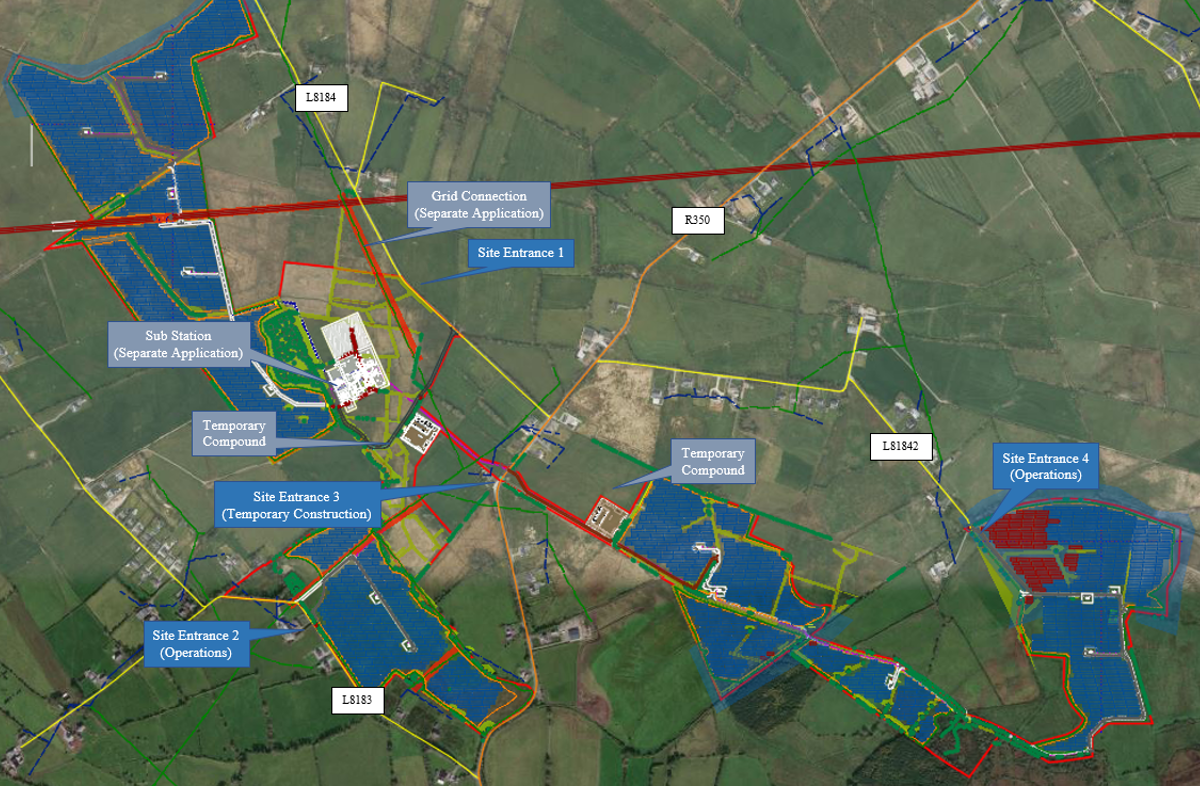
Public consultation · pre-planning phase

A proposed solar farmnorth of Loughrea, Co. Galway.

We are inviting the local community to learn about the project, ask questions of our team, and help shape the layout before a planning application is submitted to Galway County Council in Q3 2026.

6.5 km north of LoughreaTownlands of Sraheendoo, Brackloonbeg, Ben More & Galboley
Aerial view of a solar farm in rural fields

The project at a glance

The headline numbers.

At 76 MWp, the Loughrea Solar Farm will produce enough clean electricity to power around 18,000 Irish homes — every year, for decades — while continuing to allow low‑level grazing across most of the site.

247 acres
Total site area
Across 21 enclosed fields (~100 hectares)
173 acres
Solar array area
Set back from homes & roads (~70 hectares)
76 MWp
Installed capacity
Peak generating capacity of the project
~18,000
Irish homes powered each year
Equivalent annual electricity consumption
~21,000 t
CO₂ avoided every year
Cleaner air across the region
≈ 4,500 cars
Diesel cars off the road
Annual emissions equivalent

Figures based on typical yields for Irish ground‑mounted solar (≈1,000 kWh per kWp installed), an average household consumption of 4,200 kWh/yr, and the SEAI 2024 grid emissions factor for displaced electricity.

Where it is

6.5 kilometres north of Loughrea town.

The site spans the townlands of Sraheendoo, Brackloonbeg, Ben More and Galboley in County Galway. It is a relatively flat patchwork of fields enclosed by mature hedgerows and treelines, currently used for agricultural grazing.

Access will be from the R350 and L8184, approached via the M6 and N65. Five carefully designed entrances are proposed.

County
Galway
Nearest town
Loughrea
Distance to town
6.5 km north
Primary access
R350 via M6 / N65

Site boundary

The site boundary is shown in red on the OSI map, surrounding the townlands of Sraheendoo, Brackloonbeg, Galboley and Ben More.

Ordnance Survey Ireland map showing the Loughrea Solar Farm site boundary outlined in red, in the townlands of Sraheendoo, Brackloonbeg, Galboley and Ben More — 6.5 km north of Loughrea town
Site location · OSI topographic basemapTap to view full size · © OSI / Tailte Éireann

Why this project

Why building this solar farm matters.

The numbers above tell a clear story. Solar projects like Loughrea are one of the fastest, cleanest and most reversible ways for Ireland to hit its climate and energy security targets — and to build local resilience along the way.

Around 18,000 Irish homes powered every year

76 MWp of clean electricity, generated quietly in the Galway countryside, feeds straight into the national grid — every year, for decades.

Roughly 21,000 tonnes of CO₂ avoided annually

That's the equivalent of taking around 4,500 diesel cars off Irish roads — every single year. Cleaner air for the region, and a real contribution to Ireland's 2030 climate targets.

Less reliance on imported fossil fuels

Home‑grown renewable generation insulates Irish households and businesses from global gas price shocks, and helps meet the country's commitment to 80% renewable electricity by 2030.

Better land outcomes, not worse

Reduced stocking helps soils recover. Mature hedgerows are kept and bolstered, an Annex I Molinia meadow is protected, and a Biodiversity Enhancement Management Plan creates new habitat.

4,500
diesel cars

Equivalent annual emissions removed from Irish roads

21,000 t
CO₂ / year

Avoided greenhouse gas emissions, displacing grid generation

76 GWh
clean electricity / year

Enough for ~18,000 Irish homes' annual usage

Site & panels

The fields keep their character — just with panels above them.

Panels are mounted on slim steel piles driven into the ground. Rows are angled and spaced so sunlight reaches the ground, allowing vegetation to grow and low‑level grazing to continue.

Hedgerows and treelines are retained as natural screening, and the noisiest equipment (transformer / inverter stations) is located away from residential properties to preserve the quiet rural setting.

  • Approx. 3.0 m maximum height — well below tree and hedgerow level
  • Approx. 0.8 m ground clearance — keeps the soil and vegetation alive
  • Steel piles — fully removable at end of life
  • Mature hedgerows (~4 m) retained as natural screening
  • Set‑backs from homes & roads, low‑level grazing continues
≈ 3.0 m≈ 0.8 mground clearance≈ 4 mPanel arrayMounted on steel pilesVegetation & low grazingSoil recovers, biodiversity growsHedgerows retainedNatural screening from view
Indicative cross-section — typical heights shown

Indicative layout

How the solar arrays sit within the existing field pattern.

The aerial overlay below shows our current indicative layout. The solar arrays (in blue) follow the existing field boundaries wherever possible — leaving hedgerows, mature trees and sensitive habitats untouched. Site entrances, the sub-station and the grid connection are labelled directly on the map.

Aerial satellite map of the Loughrea Solar Farm site showing the indicative solar array layout in blue, with labelled site entrances, sub-station, temporary compounds and grid connection annotations
Indicative site layout · aerial basemapTap to view full size · subject to refinement

The full picture

How the project will be built — and how it sits with its neighbours.

The boxes below summarise each assessment we are carrying out. We are deliberately publishing this in plain language at the pre‑planning stage so the community can ask questions, raise concerns and help shape the final layout.

Transport & traffic

Access via the R350 and L8184, approached from the M6 and N65. No oversized loads — panels arrive by standard HGV. A Traffic Management Plan will set haul routes, safety procedures and road-cleaning measures to keep disruption to a minimum.

Landscape & visual

A Landscape & Visual Impact Assessment is underway. The enclosed nature of the fields already screens much of the project; new hedgerows will be planted and existing ones strengthened.

Glint & glare

Specialist modelling identifies any potential glint and glare effects along roads and at homes. Where needed, panel orientation and screening will be adjusted to remove the effect.

Residential amenity

Panels are set back from homes and screened by hedgerows. The site is very quiet in operation.

Biodiversity & habitats

Mature hedgerow, trees, small woodland, wet drains, peatland and Annex I Molinia meadows have all been identified and avoided in the layout. A Biodiversity Enhancement Management Plan (BEMP) will protect and improve these areas.

Key design factors

Generous set-backs from homes and roads, avoidance of valuable habitats, flood-risk mitigation, row spacing for vegetation, set-backs from hedgerows, drainage that mirrors existing greenfield run-off, and avoidance of registered heritage sites.

Construction

18 – 24 months of works, then decades of quiet operation.

A Community Liaison Officer will work with residents throughout construction, keeping people updated and handling queries. A dedicated Traffic Management Plan will be in place.

  1. Step 01
    Site preparation
    Fencing, access tracks, drainage
  2. Step 02
    Deliveries
    Panels & components by HGV
  3. Step 03
    Installation
    Steel piles & frames, then panels
  4. Step 04
    Energisation
    Cabling, inverters, grid connection
  5. Step 05
    Restoration
    Re-seeding, hedgerow planting

Planning process

Where we are — and what happens next.

We are at the pre‑planning stage. That means the project is still being shaped, and the community’s questions matter. The further ahead of the application we hear from you, the more we can do with that feedback.

  1. In progress

    Environmental surveys

    Terrestrial ecology, habitats, bats and badgers, flood-risk assessment and hydrology surveys are underway across the site.

  2. In progress

    Public & statutory consultation

    Pre-planning conversations with Galway County Council, NPWS, EPA and IFI are ongoing. This website and information days are part of the public phase.

  3. Next

    Refine the layout

    Feedback from surveys and the community is fed back into the design. The layout you see today will continue to evolve before submission.

  4. Q3 2026

    Planning application

    A full planning application will be submitted to Galway County Council in the third quarter of 2026. The substation will be a separate application.

  5. After consent

    Construction & operation

    Subject to consent: 18–24 months of construction, followed by decades of clean generation. End of life — piles removed, fields reinstated.

About the developer

Loughrea Energy Ltd, owned by Obton.

Loughrea Energy Ltd is the company taking the project forward. It is owned by Obton, an established international solar developer founded in 2009 with offices including in Ireland. The project is being developed in conjunction with local landowners.

2009
Obton founded
2,155 MW
Solar in operation globally
1 GW
Ireland pipeline
Tuam
Energy Park, Co. Galway
Ballycrissane
Solar farm, Co. Galway
Local
Landowner partnerships

Information days

Meet the team in person and ask anything you want.

We’re holding two in‑person information days at the Lough Rea Hotel & Spa in Loughrea. Each 30‑minute slot is reserved for one party (up to 4 people), so it’s a private session with the project team. Pick a day, pick a free time slot, and tell us who’s coming.

Venue

Lough Rea Hotel & Spa

Athenry Rd, Loughrea, Co. Galway H62 Y189

Open in Google Maps →

Format

30‑min private sessions

Each slot is reserved for one party of up to 4 people — just your group and the project team.

1 · Choose a day

2 · Pick a 30‑min slot

3 · Your details

Pick a day and a time slot to enable booking.

Ask a question

Can’t make an information day? Send us a note.

Use this form for general questions, observations, or anything else you would like to raise with the project team. Your message goes directly to the Community Liaison Officer.

Common questions

The questions we get asked most often.

Don’t see your question here? Send it via the message form above or raise it in person at one of the information days.

Get in touch

Speak directly with our Community Liaison Officer.

Frank is your dedicated point of contact for the project — call, email or come and meet him at one of the information days. He’ll answer any questions and pass them on to the rest of the team.

Community Liaison Officer
Frank Donnelly
Loughrea Energy Ltd.

For media enquiries or formal submissions in advance of the planning application, please use the message form above so we can route your enquiry to the right person.

Made with Emergent